How to encompass a city, and which boundary line, image, or description is the truest? These have emerged as pertinent questions during an initial meeting between the four artists who have been commissioned for The Expanded City. Over the coming months Gavin Renshaw, Olivia Keith, and Ian Nesbitt & Ruth Levene, will be developing new work responding to the housebuilding and associated infrastructure programme that has been undertaken around the outskirts of Preston as part of the government’s City Deal scheme. Preston as an urban centre is hedged by the rural, and envelops estates and suburbs that have cultivated individual identities through a combination of class, cultural and environmental delineations. As a one-time industrial hub and administrative centre, the architecture of central Preston combines the grand civic styles favoured by nineteenth century philanthropists alongside the swooping concrete of 1960s utopian brutalism and 1990s utilitarian breeze-block shop units, each in their own way designed for the use and/or edification of the people.
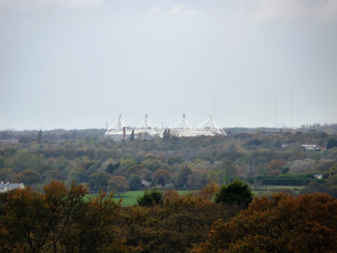
However, it is the outskirts and the edges that this project will focus on, and in the first stages of their research, each of the commissioned artists has endeavoured to navigate these areas of flux. Renshaw has photographed Preston from various points along the Guild Wheel, a 21 Mile cycle path that encircles the city, and serves as a legacy for the 2012 Guild celebrations – Preston being the only place that continues to celebrate this civic occasion dating from the rule of Henry VIII – producing images that constitute a decontextualised portrait of the City, often appearing to be ahistorical and timeless. In one image what appear to be primeval forests encroach upon the Deepdale Stadium, in an illusion created by Moor Park, that was once a moor on the edge of the growing town. Renshaw has an enduring interest in cycling advocacy, and audax cycling that was popular with the Clarion cycling clubs of the early 20th century, when groups would navigate the countryside by church spires and chimney stacks without the use of maps. By way of these interests Renshaw is investigating the perception of architecture in the landscape, and the notion of a romantic purity in navigating by the landscape and architectural markers that have become obsolete.
Similarly, Nesbitt who will be working in collaboration with Levene has previously undertaken journeys navigating by leylines, striving to make use of pathways that are invisible on maps. Renshaw and Nesbitt & Levene are engaged in ways of recording the landscape that subvert the official mapping and documentation that is drawn from political and infrastructural boundaries. Nesbitt’s practice is socially engaged, often driven by the people that he encounters, and in collaboration with Ruth Levene, the two artists have developed a process whereby they record journeys taken or pilgrimages made in parallel, being careful not to influence each other’s initial outputs. Levene has also previously produced work that records the landscape in a way that official maps do not, but her underlying concerns are to do with the environment in terms of climate change, making visual representations of social and economic interactions with environmental processes, such as the water cycle.
In 2013 Nesbitt and Levine collaborated on The Boundary Project, a durational walk around the official boundary of the city in which they were both based, Sheffield. Both artists felt that their separate practices had reached a point of convergence and the process of walking together and writing in parallel functioned as a way to start conversations and to ask questions. This project became a way to explore different kinds of knowing; that which is gained through orderly learning and that which is gained through experience. Furthermore, traversing this line which had been drawn by bureaucracy, rather than by tradition, leads to a questioning of the meaning of walking a path that may have little human significance, as opposed to the pure and romantic route taken on winding country paths from steeple to chimney stack. For The Expanded City Nesbitt and Levene are planning to conduct a similar walk around the current boundary of Preston, but have already run into difficulties in working out which is the most true and correct boundary, when the delineations of wards and parish differ.

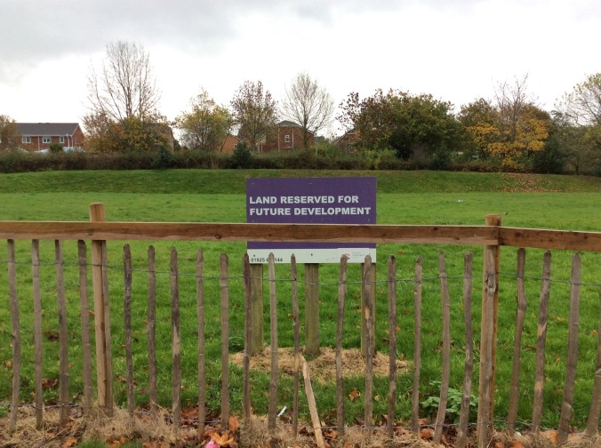
The simultaneity of official maps, and trails drawn with tradition and familiarity is central to the projects of Renshaw as well as Nesbitt & Levene, and is also important to work of Keith, who is concerned with the traces of tradition and historical context that are able to ‘make it through’ an overlaying by new development and bureaucratic re-drawing of boundaries. Keith has been walking the official public footpaths that cross through the land on the outskirts of Preston earmarked for new development, noticing and recording the idiosyncrasies of land that is in the process of transferral from public to private hands, and then back to public again. This often seems to result in what seem like glitches, where land is undesignated and waiting re-categorisation, manifesting in oddities such as a stile leading on to grass, upon which a sign reads ‘keep off the grass’. Keith is also interested in naming traditions, and the ways in which previous contexts and forgotten histories can be recorded in the naming of new street estates, pointing out that Barratt Homes’ new Canberra Lane is named after an aircraft that crashed on the site during a test flight from BAE systems, with an old stone gatepost carved into a pilot’s likeness. It is details like these that begin to form fertile ground for the creation of local myths and traditions amongst the inhabitants of these new developments.
