Expanded City Perspectives: Artist Gavin Renshaw

36-views-4k-px

At first glance, Gavin Renshaw‘s contribution to The Expanded City is the one that seems to most directly, and pragmatically relate to the potential for new infrastructure. Renshaw has a longstanding interest in cross-country cycling, using this as a tool within his art practice, and as such is personally invested in cycling infrastructure and advocacy. However, in discussing the project with Renshaw, and following the trajectory from its instinctive, habitual beginnings to the way that it has been instrumentalised towards cycling advocacy, complicates such a simple reading.

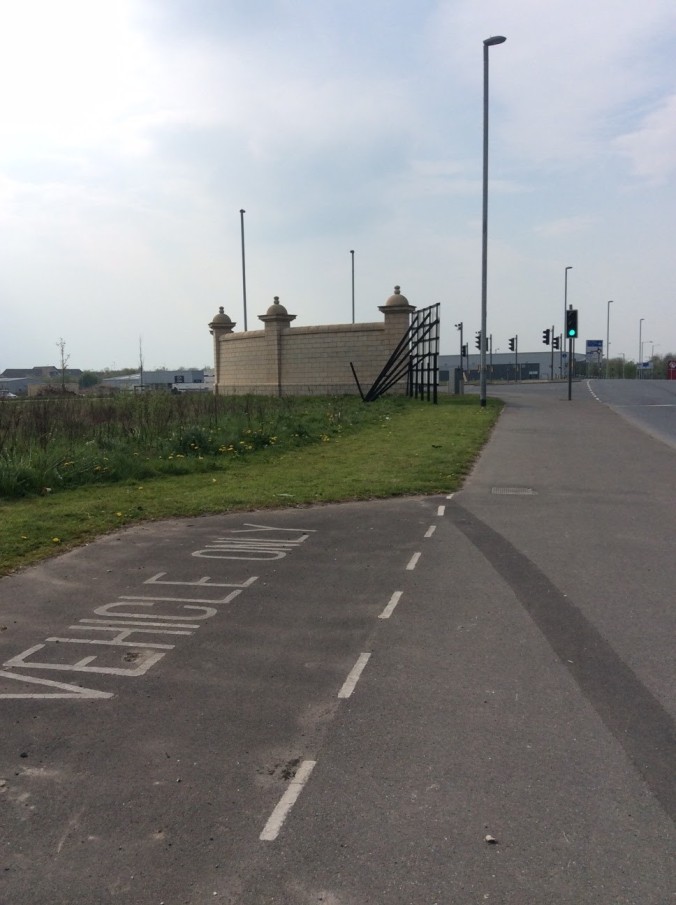
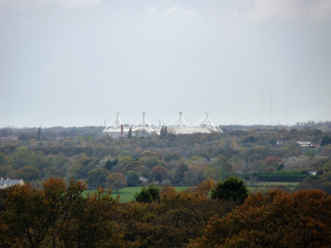
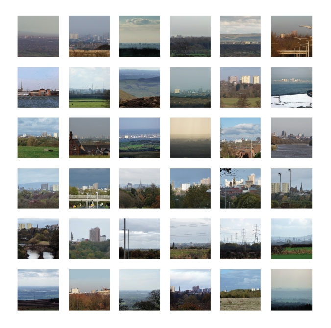
Renshaw’s initial project, of documenting distant views of Preston from various points around the periphery stems from a number of long-held concerns. An interest in architecture informs the desire to record how monumental buildings such as museums, churches and football stadiums can be brought to prominence or concealed depending on perspective. The process by which Renshaw produces his photographic images is also related to the method of triangulation, whereby accurate mapping is made possible by measuring the angles from a known point to a fixed baseline. This relates in another way to his interest in local architecture, whereby the viewpoints from which Renshaw’s images are photographed can only be noticed from a cyclist’s perspective, constituting a kind of vernacular triangulation.

This pragmatic use of architectural and natural landmarks stems from Renshaw’s desire to experiment with the different ways that architecture can be utilised and viewed. By depicting the City from a distance, and using its landmarks as triangulation points, the photographic images that Renshaw produces could be seen simply as a by-product of his research. And yet, these images have an aesthetic value beyond the distances and measurable perspectives that they portray. Taken as individual pictures, the stormy skied, or sunlit views of the landscape and city seem to point to different movements and methods in the depiction of landscape. For example, the more dramatic images taken from a high vantage point nod towards the concept of ‘the sublime’ in Romantic painting.

Although, as Renshaw asserted, these images are not meant to be viewed one by one, and it is the whole collection that constitutes the work. When viewed together it becomes clear that whilst each image is technically ‘true’, the perspective in each can completely alter the apparent make-up of the City. Different buildings and parks gain prominence depending on the angle from which they are viewed, and the temptation to settle on a single iconic depiction of the City’s skyline is thwarted. That these images come as a vast set, each framed in a similar way with the skyline centred, is reminiscent of Mischka Henner’s aerial photographs of vast oilfields and feedlots, whereby socio-politically loaded structures are reduced to distant grids.

The notion of the grid is also a useful one in thinking about Renshaw’s project, considering the way in which his photographic images are visually appealing when viewed singularly, but in agglomeration lose their narrative properties. They are also defined by the act of measurement, and depend upon the position of the observer, rather than the artists eye for their composition. As Rosalind Krauss stated in her discussion of the grid in art in 1979; “grids are not only spatial to start with, they are visual structures that explicitly reject a narrative or sequential reading of any kind.” By this definition Renshaw’s collected images when shown or considered together can be seen as a grid, that rejects narrative by proposing an overwhelming multitude of viewpoints that each depict a simultaneously true and illusory portrayal.

The way that this project has developed as part of the Expanded City is described by Renshaw as an ‘offshoot’. Whilst cycling had been an incidental, yet essential part of his initial research, it is the apparent issues associated with traversing the distance from town centre to periphery that has come to the fore as the project has progressed. In it’s next stage Renshaw’s work may take the form of a roadmap for cyclists, including things like road gradients, places to lock up and bike friendly cafes. This is a pragmatic departure from Renshaw’s original project, but is linked in pointing to the practical concerns of research by bike, whilst foregrounding the importance of individual exploration and relating back to the idea of infinite perspectives. The map will constitute a separate but linked work to the photographic series, and how the latter should be presented is yet to be decided.

Lauren Velvick

The Expanded City Symposium, June 2016

As a public introduction to The Expanded City project, a symposium held on June 16 2016 reflected the research concerns of In Certain Places and the commissioned artists through the structure of the event, as well as the content. As we have found through conducting site visits to the areas earmarked for the City Deal housing developments on Preston’s outskirts, a practicality that must be taken into account is the difficulty in reaching these areas using only public transport. One of the commissioned artists, Gavin Renshaw‘s work is partly based around the cultural history of cycling, and he has often made reference to the difficulty in safely reaching the recently opened Guild Loop cycling and walking path, which circles Preston for twenty one miles. Travelling from the centre to the periphery becomes an important issue as we consider how these new developments will relate to the existing citizens and infrastructure of Preston.

As such, the logistical difficulties inherent in the choice of venues and sites for the symposium was a framework around which the day was structured, and was a decidedly positive element, allowing attendees and speakers alike to experience the sites in question first hand, in turn facilitating a deeper appreciation of the topics discussed by the speakers. The day was divided into two halves, with an initial pick-up at Preston train station in a double decker bus, which then went on to transport attendees to the first venue; Woodplumpton and District Club, which sits approximately five miles outside of the city centre. As part of the new housing schemes in question, it has been deemed necessary to provide resources for leisure and culture within the new communities that will be formed. As such, the choice of the Woodplumpton and District Club as the venue for the first, more formal stage of the day is appropriate and poignant. The Woodplumpton and District Club is an old fashioned community club, with facilities for Bowls and Tennis alongside regular activities such as art classes, whist & dominoes and the Women’s Institute. Discussing demographics and regeneration within this context begs the question; what can serve the purpose of spaces like this within new developments?

The two invited speakers that presented during the morning session gave differing but complimentary views on what constitutes a community, of why and how change occurs, and to what extent this can be controlled or directed. First came a presentation from Carolina Caicedo of The Decorators, a multidisciplinary design practice who work with local authorities and public institutions to design and deliver interventions in regeneration areas. These interventions are sensitively tailored to the surrounding community, and often offer a critique of the regeneration in question. Caicedo gave the example of Ridley’s Temporary Restaurant, a project that sought to enliven a struggling market and to facilitate communication between vendors and users. Embedded within the project were certain safeguards, designed to ensure that the restaurant would constitute more than a fashionable eatery that had been parachuted in to a struggling neighbourhood. These included instituting a ‘no bookings’ rule which meant that the limited number of seats would always be open to whoever turned up on the night. Caicedo also emphasized the problems of ill-thought out design in new public spaces, citing a project based around a new public square that had been built in the centre of a development of high-rise apartment buildings, but was underused and desolate.

The pertinent question here seems to be; how can we, in advance, design communal spaces and structures that will actually be used and useful – that will represent something attractive to the local residents. This is where the data and analysis presented by the second speaker, economist Paul Swinney, becomes particularly pertinent. Swinney showed and explained a series of data visualisations that demonstrated, demographically, how differently sized cities are structured, and offered some possible explanations as to why. In considering the areas on the outskirts of cities that are the focus of the Expanded City project, Swinney explained that there is a trade-off between the excitement, resources and employment opportunities of inner city living, compared to the space, peace and safety of the outskirts. He went on to illustrate this point with the example of a young couple who may transfer from choosing a city centre apartment to a suburban house when they decide to start a family. Considering my earlier research into the newly designated employment area to the North East of Preston, where on a sunny weekend I was surprised to find a number of adolescents having chosen this area of relative isolation for their Saturday activities, it is relevant to consider the potential second generation of inhabitants of these new estates, and how they might make use of the outdoor spaces and leisure facilities in unexpected ways.

During this first part of the day Ian Nesbitt and Ruth Levene also presented an extract from their active research project, which has been informed by an earlier practice of collaborative walking and parallel documentation. Nesbitt and Levene deal directly with the question of whether land is public or private, and the points where this differentiation becomes uncertain. Their presentation consisted of a series of photographs taken during their walks, and the reading of extracts from their parallel diaries, written strictly without input from each other. One anecdote neatly illustrated the slightly ludicrous nature of public footpaths, some of which are purposefully blocked, or may not have been used for decades; in trekking along one of these little-used paths Nesbitt and Levene passed a house whose occupant rushed out to greet them, excited that somebody was finally making use of the track.

After the morning session sustenance was provided in the form of a personable pub lunch, and the second half of the day consisted of presentations from each of the remaining artists. The attending Counsellors, local residents and cultural producers once more boarded the double decker bus and were transported to the site of Olivia Keith‘s presentation. Keith’s site specific demonstration outlined her research methods, which involve an openness to chance and serendipity. Keith has been producing large scale, outdoor drawings at sites where older designations meet newer developments, and these are then overlaid with existing and obsolete maps. Keith pointed out the ways in which her observed drawings would match up with the maps underneath in interesting and unexpected ways. This practice also constitutes a way to facilitate conversations with passers-by who live in or make use of these areas, describing how at the meeting of a motorway bridge, country lane and suburb where Keith had chosen for her presentation, she had met a number of multi-generational walkers making a pilgrimage to Bluebell Wood.

Bussed onwards from the North West to North East of Preston we alighted next at my chosen ‘nowhere monument’ that even the Counsellors didn’t seem to have an explanation for. The way in which this de-contextualised wall was reminiscent of a folly or stage set inspired me to instruct the attendees to gather on the oval of grass and wild flowers in between the wall and road to hear a reading linking this area to Robert Smithson’s Passaic, New Jersey. This site is oddly atmospheric, with a scale that lurches between human and industrial amongst the jumble of warehouses and chain cafes.

Finally, we headed further East still for a roadside presentation from Gavin Renshaw. This site was decidedly rural, with encroaching hedgerows and a lack of pavements. Following our fluorescent jacketed leader we were led single file to a point where the whole of Preston City Centre is observable in the far distance. This capacity to visually encompass a large and complex site from a distance is an important concern for Renshaw, and is interlinked with his interest in the activity and cultural history of cycling. He spoke of how, from this distance it is possible to take a technically true impression of the City, but one that is also illusory, bringing wooded areas together in distant perspective when in reality they are isolated.

This focus on the nature of representation is a relevant strand that ran through each of the presentations given throughout the day. Nesbitt, Levene and Keith have demonstrated an interest in the disunity between bureaucratic visualisation of a place, and a more intuitive form of mapping based around memory and cultural history. Similarly, the earlier presentations from Carolina Caicedo and Paul Swinney point to the ways in which data and forward planning are useful, but can come unstuck in presenting an overly simplistic and static view of a place and its inhabitants.

Lauren Velvick

The Expanded City. Roman Way, Rough Hey, Red Scar: ruins in reverse

Maps of the outskirts of Preston, and many similar towns I’m sure, exhibit little in the way of landmarks to latch on to when planning a site visit. Main roads criss cross areas designated for new construction, and lacking a reason that has to do with warehouses or offices, the only thing left to base a choice of destination on are names. Ranging from the oddly twee to the mysteriously grisly; Pudding Pie Nook to Red Scar, these names are sometimes derived from farms or woods that formerly existed at these sites, or from historically notable events that can be real, exaggerated or outright imagined. It is through the necessary naming of streets and buildings that the histories of an otherwise unremarkable area can be partially preserved. This aspect of municipal expansion and redevelopment is central to the artistic interests of Olivia Keith, who has been conducting research into the origins of local names, such as Hoyle, Blackleach and Cottam.

After a cursory scanning of maps, and keeping in mind that Preston’s guild wheel cycle path runs through many of the redevelopment sites, I settled on the semi-rural North East of Preston, recognising this as the area bordering Fulwood, where I went to school. Approaching this visit with an open mind, and consciously not looking for anything in particular, the aspect of the partially industrial, and partially rural landscape that stood out most peculiarly was presence of strange monuments, seemingly referring to nothing in particular, and unmoored culturally and historically. These take the form of outsize sandstone Viking heads flanking the entrance to Red Scar industrial estate, and a regency-meets-boom years wall that is completely adrift, hinting at  what has not yet been built.

Lauren Blog 2 1

Whilst approaching this project with fresh eyes as a writer, the fact that Preston is my hometown can’t be ignored, and as such my treatment of the place will inescapably be tinged with nostalgia and the jarring recognition of change. In his photo-essay, A Tour of the Monuments of Passaic, New Jersey (1967) Robert Smithson writes with melancholy affection for the New Jersey landscape of his youth, and some of the tendencies that he identifies in his periphery of industrial decay and rural encroachment are present in the environs of North East Preston.

“That Zero panorama seemed to contain ruins in reverse, that is – all the new construction that would eventually be built. That is the opposite of the romantic ruin, because the buildings don’t fall into ruin after they are built, but rather rise into ruin before they are built”…[1]

The concept of “ruins in reverse.”[2] has become crucial to my understanding of how these areas function for those that encounter them; the way in which a freshly built wall backs on to a dry, bare field where boys circle around and around on dirt bikes in the early summer heat. Nothing here seems settled, and the few structures that look worn and old create discord amongst the bright corrugated warehouses and lush new shrubbery.

Lauren Blog 2 2

Driving towards the ’employment area’ in the North East of Preston a road sign bears a poetic index, indicating the way towards the three industrial estates of Roman Way, Rough Hey and Red Scar. It is these areas that most clearly embody Smithson’s description of ruins in reverse, in terms of “all the new construction that would eventually be built.”[1] However, Smithson was writing about the post-industrial, suburban places of North America, where there is a very different relationship to history than in the North of England.

“Oh, maybe there are a few statues, a legend, and a couple of curios, but no past – just what passes for a future. A Utopia minus a bottom, a place where the machines are idle, and the sun has turned to glass…”[2]

This is relevant to Keith’s research, whereby a growing knowledge of the origins of place names bestows a chronology on to the streets that will come to reconfigure the land. This action could be seen to produce a bottom, and to fill in the ‘holes’, as Smithson identifies them, that pepper places like Preston; “these holes in a sense are the monumental vacancies that define, without trying, the memory-traces of an abandoned set of futures.”[3] In seeking a concrete explanation for the names of new places, and the strange ‘nowhere monuments’ that are created for them, Keith may be able to complicate the dizzy sense of forward momentum that is embodied by the ‘ruins in reverse’ of new development. In order to satirically illustrate and affirm the ‘irreversibility of eternity’ in his essay, Smithson describes a ‘jejune experiment for proving entropy’ whereby a child running in circles through coloured sand, cannot re-separate the colours by circling in the opposite direction. The perpetual circling motion evoked by Smithson is reminiscent of the boys who circle each other on their dirt bikes in Preston’s dusty fields, that will not be fields for much longer.

Lauren Blog 2 3

Lauren Velvick
The Expanded City
Previous post

[1]    Smithson, Robert. A Tour of the Monuments of Passiac, New Jersey (1967)
[2]    Smithson, Robert. A Tour of the Monuments of Passiac, New Jersey (1967)
[3]    Smithson, Robert. A Tour of the Monuments of Passiac, New Jersey (1967)
[4]    Smithson, Robert. A Tour of the Monuments of Passiac, New Jersey (1967)
[5]    Smithson, Robert. A Tour of the Monuments of Passiac, New Jersey (1967)

The Expanded City: Initial Artists’ Meeting

Photo 06-11-2015, 13 49 45

How to encompass a city, and which boundary line, image, or description is the truest? These have emerged as pertinent questions during an initial meeting between the four artists who have been commissioned for The Expanded City. Over the coming months Gavin Renshaw, Olivia Keith, and  Ian Nesbitt & Ruth Levene, will be developing new work responding to the housebuilding and associated infrastructure programme that has been undertaken around the outskirts of Preston as part of the government’s City Deal scheme. Preston as an urban centre is hedged by the rural, and envelops estates and suburbs that have cultivated individual identities through a combination of class, cultural and environmental delineations. As a one-time industrial hub and administrative centre, the architecture of central Preston combines the grand civic styles favoured by nineteenth century philanthropists alongside the swooping concrete of 1960s utopian brutalism and 1990s utilitarian breeze-block shop units, each in their own way designed for the use and/or edification of the people.

However, it is the outskirts and the edges that this project will focus on, and in the first stages of their research, each of the commissioned artists has endeavoured to navigate these areas of flux. Renshaw has photographed Preston from various points along the Guild Wheel, a 21 Mile cycle path that encircles the city, and serves as a legacy for the 2012 Guild celebrations – Preston being the only place that continues to celebrate this civic occasion dating from the rule of Henry VIII – producing images that constitute a decontextualised portrait of the City, often appearing to be ahistorical and timeless. In one image what appear to be primeval forests encroach upon the Deepdale Stadium, in an illusion created by Moor Park, that was once a moor on the edge of the growing town. Renshaw has an enduring interest in cycling advocacy, and audax cycling that was popular with the Clarion cycling clubs of the early 20th century, when groups would navigate the countryside by church spires and chimney stacks without the use of maps. By way of these interests Renshaw is investigating the perception of architecture in the landscape, and the notion of a romantic purity in navigating by the landscape and architectural markers that have become obsolete.

PNE

Similarly, Nesbitt who will be working in collaboration with Levene has previously undertaken journeys navigating by leylines, striving to make use of pathways that are invisible on maps. Renshaw and Nesbitt & Levene are engaged in ways of recording the landscape that subvert the official mapping and documentation that is drawn from political and infrastructural boundaries. Nesbitt’s practice is socially engaged, often driven by the people that he encounters, and in collaboration with Ruth Levene, the two artists have developed a process whereby they record journeys taken or pilgrimages made in parallel, being careful not to influence each other’s initial outputs. Levene has also previously produced work that records the landscape in a way that official maps do not, but her underlying concerns are to do with the environment in terms of climate change, making visual representations of social and economic interactions with environmental processes, such as the water cycle.

In 2013 Nesbitt and Levine collaborated on The Boundary Project, a durational walk around the official boundary of the city in which they were both based, Sheffield. Both artists felt that their separate practices had reached a point of convergence and the process of walking together and writing in parallel functioned as a way to start conversations and to ask questions. This project became a way to explore different kinds of knowing; that which is gained through orderly learning and that which is gained through experience. Furthermore, traversing this line which had been drawn by bureaucracy, rather than by tradition, leads to a questioning of the meaning of walking a path that may have little human significance, as opposed to the pure and romantic route taken on winding country paths from steeple to chimney stack. For The Expanded City Nesbitt and Levene are planning to conduct a similar walk around the current boundary of Preston, but have already run into difficulties in working out which is the most true and correct boundary, when the delineations of wards and parish differ.


DWainhomes stile

The simultaneity of official maps, and trails drawn with tradition and familiarity is central to the projects of Renshaw as well as Nesbitt & Levene, and is also important to work of Keith, who is concerned with the traces of tradition and historical context that are able to ‘make it through’ an overlaying by new development and bureaucratic re-drawing of boundaries. Keith has been walking the official public footpaths that cross through the land on the outskirts of Preston earmarked for new development, noticing and recording the idiosyncrasies of land that is in the process of transferral from public to private hands, and then back to public again. This often seems to result in what seem like glitches, where land is undesignated and waiting re-categorisation, manifesting in oddities such as a stile leading on to grass, upon which a sign reads ‘keep off the grass’. Keith is also interested in naming traditions, and the ways in which previous contexts and forgotten histories can be recorded in the naming of new street estates, pointing out that Barratt Homes’ new Canberra Lane is named after an aircraft that crashed on the site during a test flight from BAE systems, with an old stone gatepost carved into a pilot’s likeness. It is details like these that begin to form fertile ground for the creation of local myths and traditions amongst the inhabitants of these new developments.

Lauren Velvick